The Kettering Incident and Why I am the Smartest in the Room
Friday, 29 July 2016
 When I was between projects back in 2014, it seemed that everywhere I went there were little red and white arrow signs stuck up on intersections saying TKI. These were directional signs for the crew of The Kettering Incident - a big budget 8 part series, being filmed in Tasmania for Foxtel. When I was between projects back in 2014, it seemed that everywhere I went there were little red and white arrow signs stuck up on intersections saying TKI. These were directional signs for the crew of The Kettering Incident - a big budget 8 part series, being filmed in Tasmania for Foxtel.
And now, years after its completion, and even after it has won awards at festivals, it is finally on air - well sort of. It's on Foxtel so I can't watch it on normal TV - but between Clare and myself and foxtel 2 week-free trial subscriptions, we have been able to get hold of it and we've watched up to episode 5. The first episode told us in text that we were in "present day" Kettering, which means that it must currently be 1975. Every single thing except the mobile phones, was old fashioned in some way. Hairstyles, furniture, radios, cars, police records, and the props department must have bought the entire site's worth of CRT Tv sets from the Margate Tip Shop to put into every house and office that features on the show (what the police would have been doing with a TV set like that I don't know, but since they didn't seem to have access to any sort of computer system which might have helped them solve the weird murder cases I guess their time is just as well spent watching The Today Show in black and white) When you watch a fictional show that's been filmed in your local area it's disorienting to watch the characters travel from place to place through landscapes that are somewhere else entirely. I remember that feeling when I watched the Sydney based movie Lantana, when the characters would make frequent use of the F4 motorway (between sydney and newcastle) whilst driving between eastern shore sydney suburbs. In TKI the characters move around the greater kettering area via The Neck on Bruny Island, and the houses which are supposedly in Kettering are actually in Mountain River, so that the Sleeping Beauty Ranges could be featured in the background. All of that is pretty normal in film/TV land, but there was one shot in TKI which really caught my eye - a wide shot where the main character laments the strange disappearance of her hire car (that she had abandonned earlier, leaving it blocking a winding, narrow dirt road which is also the main road into Kettering apparently). 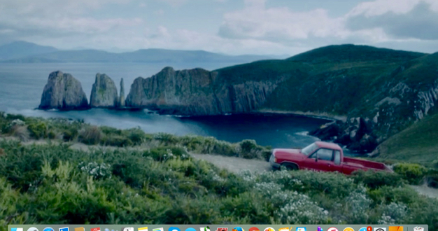
So this shot is supposed to be near Kettering. Of course it's not though, it's Cape Huay (The rocky formations themselves are known as the Candle Stick, Totem Pole and the Lanterns) which are off the Tasman Peninsula - I don't blame the movie makers for wanting to use them in the show - it's an amazing view, showcasing the foreboding yet majestic beauty of Tasmania blah blah blah. But as soon as I saw it, I knew something was especially fishy about it. I ran my suspicions past Clare who poo-pooed me, and I bounced them off someone at work called Ben, who was on set every day of the 6 week shoot. Ben was pretty sure that there wouldn't have been any money left in the budget to do what I was suggesting the director had done. Between these two nay-sayers, I could have left it there.. but I didn't, because above all I am a scientist and an investigator. Ok. I'm not either of those things but I did want to solve the mystery, and prove myself to be the smartest person in the room (which is quite hard to do when the two other people are Jon and Clare). So regular readers will know that Jon has run the Bruny Island Ultramarathon twice - a 64k run from the northern tip to the southern lighthouse. Jon is normally flagging by the last 5k, so we are usually doing a fair bit of waiting in our support vehicle. In fact it's not far from where we once threw Zali out of the car to help Jon drag his sore and sorry butt up on of the last hills.   So I know that area, and as soon as I saw it, I recognised that vegetation in the foreground of the shot from that the area leading up to the lighthouse. And that beach/coastline to the right of the rocks looked a lot like the area below the lighthouse. 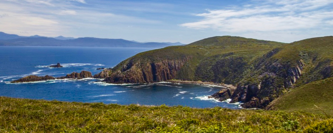 And the impressive looking rocks in the left of the background of the shot? Well, aside from the fact that they are on a completely different peninsula of land altogether, they really do look like that. But only if you are looking at them from a boat. They actually face out to the south, not to the road side. This is what they look like from the land side..much less impressive I'm sure you will agree. 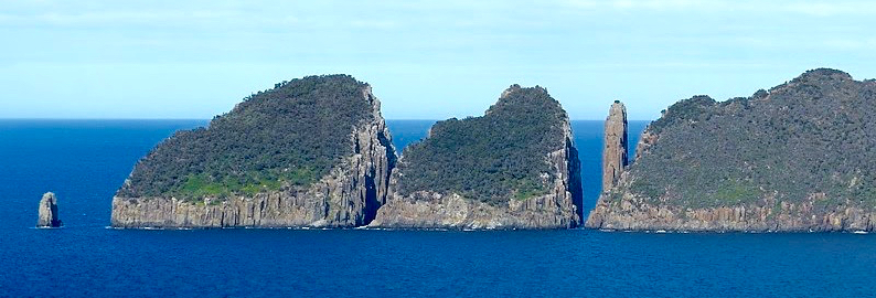 From the southern ocean side, the rocks do look like this (thanks internet for the photo): 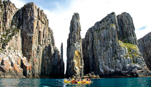
I put it to you, members of the jury, that THIS shot, is actually Cape Huay, flipped around to face north, stuck onto the end of Bruny Island, and called Kettering. And they thought they'd get away with it. Not on my watch. 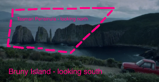
The image below is an enhanced, zoomed in screen shot - showing the actual area where they made their join. 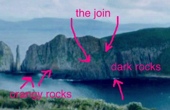
So in resting my case I prove to you, without a shadow of a doubt, that despite occasional evidence to the contrary (like the time I cancelled one of my cake courses at the last minute and accidenatly emailed all the notifications to myself rather than my students, or my constant use of the word Recon when I actually mean Reckon), that I am actually the smartest person in the room - at least I was last night. Thankyou. |